| |
|
|
|
|
|
|
|
|
About Sunderban-1 |
|
UNESCO has decleared the Sundarbans a world Heritage site.
The largest single block of tidal halophytic mangrove forest in the world, located in the southern part of Bangladesh. It lies on the Ganges-Brahmaputra Delta at the point where it merges with the Bay of Bengal . The forest lies a little south to the Tropic of Cancer between the latitudes 21ş30´N and 22ş30´N, and longitudes 89ş00´E and 89ş55´E. With its array of trees and Wildlife the forest is a showpiece of natural history. It is also a centre of economic activities, such as extraction of timber, fishing and collection of Honey. The forest consists of about 200 islands, separated by about 400 interconnected tidal rivers, creeks and canals.
The Sundarbans was originally measured (about 200 years ago) to be of about 16,700 sq km. Now it has dwindled to about 1/3 of the original size. Because of the partition of India, Bangladesh received about 2/3 of the forest; the rest is on the Indian side. It is now estimated to be about 4,110 sq km, of which about 1,700 sq km is occupied by waterbodies. The forest lies under two forest divisions, and four administrative ranges viz 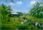 Chandpai, Sarankhola, Khulna and Burigoalini and has 16 forest stations. It is further divided into 55 compartments and 9 blocks. The Sundarbans was declared as a Reserve Forest in 1875. About 32,400 hectares of the Sundarbans have been declared as three wildlife sanctuaries, and came under the UNESCO World Heritage Site in 1999. These wildlife sanctuaries were established in 1977 under the Bangladesh Wildlife (Preservation) (Amendment) Act, 1974. These are Sundarbans West (9,069 ha), Sundarbans South (17,878 ha), and Sundarbans East (5,439 ha). The Sundarbans was originally measured (about 200 years ago) to be of about 16,700 sq km. Now it has dwindled to about 1/3 of the original size. Because of the partition of India, Bangladesh received about 2/3 of the forest; the rest is on the Indian side. It is now estimated to be about 4,110 sq km, of which about 1,700 sq km is occupied by waterbodies. The forest lies under two forest divisions, and four administrative ranges viz Chandpai, Sarankhola, Khulna and Burigoalini and has 16 forest stations. It is further divided into 55 compartments and 9 blocks. The Sundarbans was declared as a Reserve Forest in 1875. About 32,400 hectares of the Sundarbans have been declared as three wildlife sanctuaries, and came under the UNESCO World Heritage Site in 1999. These wildlife sanctuaries were established in 1977 under the Bangladesh Wildlife (Preservation) (Amendment) Act, 1974. These are Sundarbans West (9,069 ha), Sundarbans South (17,878 ha), and Sundarbans East (5,439 ha). Chandpai, Sarankhola, Khulna and Burigoalini and has 16 forest stations. It is further divided into 55 compartments and 9 blocks. The Sundarbans was declared as a Reserve Forest in 1875. About 32,400 hectares of the Sundarbans have been declared as three wildlife sanctuaries, and came under the UNESCO World Heritage Site in 1999. These wildlife sanctuaries were established in 1977 under the Bangladesh Wildlife (Preservation) (Amendment) Act, 1974. These are Sundarbans West (9,069 ha), Sundarbans South (17,878 ha), and Sundarbans East (5,439 ha). The Sundarbans was originally measured (about 200 years ago) to be of about 16,700 sq km. Now it has dwindled to about 1/3 of the original size. Because of the partition of India, Bangladesh received about 2/3 of the forest; the rest is on the Indian side. It is now estimated to be about 4,110 sq km, of which about 1,700 sq km is occupied by waterbodies. The forest lies under two forest divisions, and four administrative ranges viz Chandpai, Sarankhola, Khulna and Burigoalini and has 16 forest stations. It is further divided into 55 compartments and 9 blocks. The Sundarbans was declared as a Reserve Forest in 1875. About 32,400 hectares of the Sundarbans have been declared as three wildlife sanctuaries, and came under the UNESCO World Heritage Site in 1999. These wildlife sanctuaries were established in 1977 under the Bangladesh Wildlife (Preservation) (Amendment) Act, 1974. These are Sundarbans West (9,069 ha), Sundarbans South (17,878 ha), and Sundarbans East (5,439 ha).
The Bangla word ban means forest, and the name Sundarban was coined either from the forests of Sundari tree ie Sundari-ban, or from the forests of the samudra (sea) ie, Samudra-ban, or from its association with the primitive tribe Chandra-bandhe which was corrupted into Sundarban. The generally accepted explanation, however, is its derivation from the Sundari tree, the most common tree in these forests.
Geology The tract of the Sundarbans is of recent origin, raised by the deposition of sediments formed due to soil erosion in the Himalayas. The process has been accelerated by tides from the sea face. The substratum consists mainly of Quaternary Era sediments, sand and silt mixed with marine salt deposits and clay. Geologists have detected a southeastern slope and tilting of the Bengal basin during the Tertiary. Because of neo-tectonic movements during the 10th-12th century AD, the Bengal Basin titled eastward. Evidence from borehole studies indicate that while the westernside of the Sundarbans is relatively stable, the southeastern corner is an active sedimentary area and is subsiding.
Soil Soils of the Sundarbans mangrove forest differ from other inland soils in that they are subjected to the effects of salinity and waterlogging, which naturally affect the vegetation. In places soils are semi-solid and poorly consolidated. The pH ranges widely from 5.3 to 8.0. Although the Sundarbans soil is in general medium textured, sandy loam, silt loam or clay loam, the grain size distribution is highly variable. Silt loam is dominant textural class. Sodium and calcium contents of the soil vary from 5.7 to 29.8 meq/100g dry soil and are generally low in the eastern region and higher towards the west. The available potassium content of the soil is low, 0.3-1.3 meq/100g dry soil. Organic matter content varies between 4% and 10% in dry soil. Soil salinity increases from east (slight to moderate) to west (highly saline), but the salinity is not uniform from north to south throughout the forest.
Climate Since the forest is located on the south of the Tropic of Cancer and bounded by the northern limits of the Bay of Bengal, it is classified as tropical moist forest. The temperatures in the Sundarbans are fairly equable than those of the adjacent land areas. The average annual maximum and minimum temperatures vary between 30ş and 21şC. High temperatures occur from mid-March to mid-June and low in December and January. The mean maximum temperature for the hottest months has been recorded as 32.4şC at Patuakhali, in the east of the Sundarbans.
The mean annual relative humidity varies from 70% at Satkhira to 80% at Patuakhali. Humidity is highest in June-October and lowest in February. Annual rainfall in the Sundarbans is in the range of 1640-2000 mm, rainfall increases from west to the east. Most rainfall occurs during the monsoon from May to October. Frequent and heavy showers occur from mid-June to mid-September. Often storm accompanied by tidal waves result widespread inundation and cause damage to vegetation and animal life.
Vegetation The vegetation is largely of mangrove type and encompasses a variety of plants including trees, shrubs, grasses, epiphytes, and lianas. Being mostly evergreen, they possess more or less similar physiological and structural adaptations. Most trees have pneumatophores for aerial respiration. The prominent species is Sundari (Heritiera fomes) and Gewa (Excoecaria agallocha). Of these 17 are pteridophytes, 87 monocotyledons and the rest are dicotyledons. The plant species include 35 legumes, 29 grasses, 19 sedges, and 18 euphorbias. Of the 50 true mangrove plant species recorded, the Sundarbans alone contain 35. Almost all mangrove plant species are evergreen, dwarf, shrubby or tall trees, and grow gregariously without leaving any space on the floor.
In the Sundarbans the saltwater forest is situated in the south-western part where Gewa (E. agallocha), Goran (Ceriops decandra), Keora (Sonneratia apetala), Ora (S. caseolaris), Passur (Xylocarpus mekongensis), Dhundul (X. granatum), Bain (Avicennia alba, A. marina, A. officinales), and other rhizophores, and Hantal (Phoenix pelludosa) dominate. The typical mangrove species dominate the central part of the forest. The moderate saltwater forest covers most of the southern parts of Khulna and Bagerhat districts where Sundari is the dominant species.
There is a thick mat of the Nipa Palm or Golpata (Nipa fruticans) by the side of almost all the canals. The moderately freshwater zone results from the large amount of water, which flows down the Passur, Haringhata and Burisher, maintaining the surface water at a lower level of salinity.
The Sundarbans shows some distinct phyto-succession, where the newly formed lands are occupied by some pioneer species viz Leersia hexandra, wild rice (Potresia species), followed by Avicennia, Sonneratia and Aegiceras. The secondary succession occurs due to Ceriops, Excoecaria, Bruguiera, Heritiera, Xylocarpus and Rhizophora. Tiger fern (Achrostichum aureum) mostly covers the ground floor, which is common in saltwater and moderately saltwater zones. Tigers use these bushes to camouflage themselves. |
|
|
|
|
|
|
|
|
|